
Back on Waterloo Station where I am due to meet my friend Caramel. This time the tube was not so smooth, I went up to Archway in good time to find it was the dreaded rail replacement bus as far as Camden. Still I made it in time to get my ticket from a machine (having abandoned the huge queue in the ticket office) but no Caramel. There are however a lot of people dressed as jungle animals and hunters - people dressed as lions and as crocodiles, people wearing pith helmets, and a whole bunch of apparantly unrelated people dressed up in stuff that is nothing to do with safari's.
View Godalming to Liphook in a larger map
But no Caramel. Eventually it occurs to me to check the mobile and see there are several messages. Her tube has got stuck because of a signal failure. I buy her ticket and a bit later she arrives. We have missed the target train but there is another along shortly afterwards. Caramel has interrogated some of the animal costume people and apparently it is something to do with rugby.
We have an uneventful run to Godalming where we go first into town so I can buy a better map. WH Smith's in railway stations no longer seem to carry OS maps - but the big one in Godalming has the right one.

 And then we set off for a fairly uninspiring road walk to Milford, passing a church with a surprising
 mausoleum but little else of especial interest.
 Out of Milford, however and across a busy road we go up a small cul-de-sac that takes us over the A3. and
then turns into a dirt track as it skirts Mousehill Down
 There is a bit of what is marked as open country on the map but it turns out to be what looks like a
 Christmas tree plantation. Caramel says her kids would love it. Around here Simon her husband (who is looking after the kids) calls her on her super-smart-phone to ask for important information about cous-cous measurements.

At the entrance to Bagmoor Common is a sign warning that areas have been fenced off for grazing. And we
 soon come to one. It appears to be an electric fence with a very narrow entrance consisting of three poles in a triangle. As Caramel says, it is not an entrance for fat people. We manage to squeeze through but it is touch and go for me!
Inside the grazing area it is more heathy with a lot of gorse in flower.

And then we hit a metaled track that runs dead straight. I am grateful for the map because there are a bewildering number of tracks and paths around.
 There are a lot marked on the map but they don't correspond very obviously to the map. The route marked on the map here is approximate because though I know where we entered Thursley Heath and where we finally exited I really am not sure which footpaths we took, or even whether they related to the paths on the map. Some of it certainly did not correspond, which is probably not surprising as casual paths soon become wide in this sandy heathland.
 Anyway, we take a path off the metaled track onto the wet heath of Thursley Common. I have been here twice before, the first time being on a field trip when I was doing a conservation City and Guilds course. Because Thursley is a national nature reserve combining dry heath with even rarer wet heath.
And it is a landscape like no other I am familiar with. Very open with wide vistas, mostly heather or sphagnum moss in the wetter parts, with the odd scots pine or patch of downy birch or gorse
http://www.naturalengland.org.uk/ourwork/conservation/designations/nnr/1006148.aspx

We puzzle over which way to go at a crossroads of paths in the Heath. Caramel offers to find out where we are from the sat nav in her phone and I have to explain to her that his is cheating and it is far better to wander about lost peering myopically at my map (because I cannot be arsed to find my glasses). These young people and their strange notions!
Eventually we compromise and I let her look at the map which she can actually see, having glasses on.
 Actually we have got to a point where nothing helps much because the paths do not relate to the map at all.
 A bunch of kids walk by. We saw them as we left Milford but they had a teacher with them then and he has disappeared. We wonder what has happened to him, coming to the conclusion that the most likely explanation is that they have killed an eaten him en route. So we hide behind a tree until they are safely past.
In contrast to the open bog there are a lot of people in the very sandy, hilly country we are now in: older people walking dogs, cannibal Duke of Edinburgh award kids, etc. The going is much tougher because it is very soft sand, and the paths have been worn very wide. Perhaps this tendency for small tracks to become wide sandy paths is why the map is being so difficult today.

 Fortunately, though I have no real idea which path we might be on, and sat nav is clearly cheating, we can now hear the A3 again and that orients us. This makes it lucky that I bought the new map because on the old 50,000 OS I had the A3 is not in exactly the same place.
 By some sort of miracle we come out of Thursley Heath by a house called Foldsown at pretty much the precise place I had originally planned to, after being completely unsure about what path we were on for about three quarters of the way.
I try not to look too surprised and we are pleased to see some bluebells in the wood across the road.
 Because of the late start it is getting quite hungry, and the sky is darkening alarmingly too. We decide to poke our heads into the Three Horseshoes. I had checked this out online and the food looked promising but there were no vegetarian mains on the menu, and Caramel is a vegetarian. But she decided on a sandwich and I had some English asparagus that came with nothing but parmesan. Fortunately caramel gave me half her enormous sandwich and it did
 very well.
The place was fairly rammed and I was a bit worried we would be waiting ours for food but the service was remarkably efficient and the food good (though I would have cooked the asparagus a little more, myself).
 We leave to moderately heavy and distinctly cold rain, trudging down the little road past Thursley Church and then on to a byway getting a little tangled with a party of walkers. We soon outstrip them though as the track begins to rise.
 The track is tree lined and often quite a deep cut hollow way - though it is not as deep as I remember and I realise that I must have come out by a parallel track on my previous visit.
 That is a bit of a pity as it was a phenomenally deep defile. But this route has its compensations, including
anciently laid beech that suggests it was an old drove, and highland cattle in the field to the side.

We have been going steadily uphill for a while. I expect it to drop us into the Devil's Punch Bowl but it doesn't because I am going by memory rather than the contour lines that I cannot see properly without my
glasses. Also having changed from 50,000 scale to 25,000 is messing up my distance estimation. And the memory is wrong because we are on a different footpath!

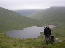
But it is all good because this route means that we start traversing the side of the Devil's Punch Bowl with
views into and across it to the tree covered slopes the other side of the (hidden) Youth Hostel.

 We come to a tiny road that winds up and little house that enables me to establish where we are exactly. More uphill and this is not steady it is a grind.
 Caramel does better than me but we are both panting by the time it levels off.

Last time I was here the beauty of the place was marred by the roaring of traffic from the A3 as it skirted the
eastern edge of the Punch Bowl. Amazingly it has gone. diverted through a tunnel. We pass the line of what must be the old A3, filled with soil and greening with lots of trees planted.
A little above it we hit the old turnpike which must have been replaced by the A3 and is now after who knows how many years interruption, the road to Portsmouth again. Well, at least a little bit of it for walkers and cyclists.
 I am really pleased by this. So little consideration is
shown to pedestrians and so much to cars and lorries, and the idea that the tunnel has been built to take the traffic away from the walkers http://www.bbc.co.uk/news/uk-england-surrey-14298318
and riders around this exceptionally beautiful area is a great one. However, when I check it out it turns out that it was because there was a traffic pinch point at Hindhead.
Oh well, whatever the reason, the effect is absolutely great. And this bit of the walk is outstanding. The rain has stopped, the views across the punch bowl and sometimes far, far beyond it, are fantastic, and the lighter green scar of the old A3 is almost an
enhancement as it reminds me of how much better this is than it would be without the tunnel.
At some point around now, Caramel has to answer the phone again. This time it is a friend with a question about whether or not she should wear pants or not. This is, it seems not a general question about the advisability of knickers but a more specific (and frankly even stranger) query. The friend is doing a cycle ride and has been informed, Caramel tells me, that it is a good idea to smear her more intimate parts with something that is known technically as "minty arse lard," before serious cycling expeditions.
Which all makes perfect sense but, apparently the friend is concerned that the minty arse lard might disappear into her bits without pants. This makes no sort of sense to me because, it seems to me that pants would make no difference to the minty arse lard disappearing into your bits potential problem unless you smeared the minty arse lard over your pants.
Which would just be silly, surely?

However, I neglect to ask Caramel this for fear of looking like a damned lubber (I am re-reading Patrick O'Brian books). Pants advice administered, we continue on our way.
We come to a view with a memorial marking where two men were hung for murdering a sailor.
And shortly afterwards we come to the new National Trust cafe.
 This is most welcome. Having been walking on the flat with sporadic showers and a cold wind it is very pleasant to go into the warm cafe to have coffee and
 extremely expensive cake but very nice (don't worry, Caramel paid).
 Today has been much more complicated navigationaly than any other day of this walk, already. The first day needed none as I knew the entire route. The second had the problem of getting off the A3 into Richmond Park but that was an isolated glitch. The last two days involved following tow paths along the Thames and then the Wey Navigation and involved no navigation at all (despite the
 name).
 Today has been a bit harder but it is about to get a lot more complicated. I discuss it with Caramel. The most appealing way seems to involve going down something called the Golden Valley. But there is a snag. That goes so far as access land and then there is neither access land marked nor rights of way. It is woodland and you never know with woodland, there might well be a path. But I don't really like the look of it (and I have got my glasses on).
We decide on balance to take the chance and start out. One advantage of this route is that we continue
around the rim of the Devil's Punch Bowl for a bit longer. Then we take a little road off, past some houses, cross a busy road and find a path down into the Golden Valley.

This is lovely, but also a bit ominous. We have climbed a long way up to the rim of the punch bowl. And the
path goes down and down and down. Not that I mind down at this sort of gradient but I am aware that we will have to go up again. Still for now it is very pleasant walking through trees freshly in leaf.
 But at the bottom we hit a great big fence. There are cameras, a road and a big house beyond. Clearly the non-access land on the map is an enormous woodland garden. One of the major failings of the CROW access law was exempting woodland. We can't continue so it is left or right.
After a moments thought we opt for right, there is a very small, rough path winding up the hill, we start up and I am soon out of breath but also I realise that this is foolish. Yes there is a clear way if we get up to the top but it we are climbing the wrong side of the valley. We will have to dip down and up again.
 So we decide to retrace our steps and take the other side, though it is going to be much harder to find the
 way.
It is a hard steep grind up the hill. But the navigation problem is worse. Tiny branching paths through thick woodland. This gets worse once the land levels off (because at least we have the slope to gauge things with). As we get more confused Caramel gets out her compass and we use that for a while.
But something isn't right. I can't quite believe that what her compass tells us is South really is. So I get mine out. They don't agree at all. Caramel tries holding hers out further from her body and it starts to agree with mine. She has been drinking from a Camelbak all day, and, it turns out, that the drinking tube has a http://shop.camelbak.com/store/landing.aspx?categoryid=754
magnetic clip
And, of course, the magnetic clip has sent the compass mental!
So on we go, aware now of the problem. It is still pretty bewildering but then we get a glimpse of a church through the trees. It is over a side valley and we try to find a way round this but in the end give up and go down before climbing up again.

And emerge on a little road with houses, including one called Woodcock Cottage. There is a Woodcock Bottom round here somewhere, I seem to remember, but not marked on this map.
 The road in turn leads us to a big road. It is pretty clear that we are in Greyshott now but none of the shops have any village name on them. What is less clear is where we are on the main road, because we cannot see the church now. So we ask a man if this is Greyshott and he tells us it is. But I neglect to ask him where the church is.
However I am fairly confident (Greyshott is not that big) and we set off down the road in the direction I think
right, and soon enough we do come to the church.

Completely confident of where we are we dive off down a byway, this one with houses on it for the first
stretch.

I get a bit confused as I am still over-compensating for the map scale change but Caramel puts me right. And
we settle into a very pleasant woodland walk for a kilometer or so until we reach the top of string of little artificial ponds.
 These lead to a car park at Waggoners Wells and we cross a minor road to some much bigger ponds which
a sign informs us are thought to be "hammer ponds" reservoirs for driving a water powered forge hammer.
http://www.grayshott.com/wordpress/waggoners-wells/
The track turns into a minor road, and I manage to miss the point where the minor road splits from a byway

I am a bit worried in case we scamper across to an impenetrable barrier but it is (as Caramel points out) a duel carriageway and fortunately there is no barrier in the central reservation, and we get over it easily enough.
 And find ourselves on M.O.D. "managed access land." There is a sign warning us not to pick up bombs or play cricket with grenades, but there are no red flags around so we press on across the access land. And it is pleasant open woodland.
We find a slightly muddy track at the side of a house and this takes us down to a minor road.
 This leads us past a trout farm and then we leave it for a byway that
takes us under the railway before running at the side of it.
This pleasant walking is interrupted by the B2131 this proves to be busier than I expected and the cars are going too fast for comfort. We are glad to get off it for a little bit of byway, that leads to a much quieter minor road.
 We are both feeling the exertion now. But the walking is fairly flat and
 it is a quiet country road that soon evolves into a quiet suburban one.
Finally there is a stretch of B road up to Liphook station. But this is suburbia now and it has a pavement.


We have to wait a while for the train, but there is a seat and (cold) hot cross buns. And when it does come it
is not crowded so we can trundle back to London in comfort. There are even a few safari people left, presumably coming back after their day out, at Waterloo Station.
That was a great walk. It was lovely to have company for a change. Thursley is a truly unusual environment and the Devil's Punch Bowl is amazing. I can never quite believe that it is in Surrey, it seems too wild and rugged.

Caramel's panorama of the Devil's Punch Bowl.
2 comments:
Subscribe to:
Post Comments (Atom)


What a lovely walk! Will try to get tob he punch bowl, amazing photos.
The cycle was great with lots of minty lard, on the inside of the shorts with no pants (slight private disappearing, but no apparent side effects)
Caramel's lardy-arsed friend x
He he, thanks for the comment. Caramel has pointed out that it was a text conversation rather than a phone call - about whether you should wear pants - she seemed to think that I had not made this sufficiently clear.
Glad the cycle ride was great.